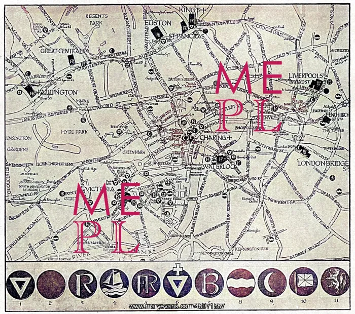


 : Map of YMCA shelters around London during WW1


Map of YMCA shelters around London during WW1

A map showing the various YMCA huts available for soldiers and sailors in the capital on leave during the First World War, though The Graphic magazine, who published this picture, note that there were far more (in 1917) than when the map was originally compiled by the Civic Survey of Greater London for the City of London National Guard, who have done great excellent work as cicerones for returning warriors

Picture No
14105708
Media ID
45971557
Size
4700px x 4160px (2.5MB)
Credit
Mary Evans Picture Library
Source
Illustration from The Graphic, 30 December 1916
Date
1917

Pick your License

Please tell us the book title or ISBN

Please supply intended use


Accommodation Civic Clubs Huts Shelters Survey Ymca


Features In These Collections

> Contributors > COM
Gallery Wall Inspiration

HERBERT SCHIRMER
LORENZO RICCI
Carnival in a street in Rome, Italy
SARAWAK / BROOKE HOME
Rome saved from Gauls by geese
LAMBALLE (FREEMAN)
Schirmer abduction, 1967
UFOS/ADAMSKI
BRITISH OFFICIAL, INDIA
Turkish Soldiers
WALLENSTEIN'S CAMP
WALL STREET (SCHILLING)
HOMER/THEVET/1584
ARMING A KNIGHT
FAUJAS DE SAINT-FOND
Albert Richard Smith
Paris, France - Hotel de Ville
1st Earl of Strafford
LLOYDS - MAIN HALL
MARCO POLO/DISGUISE
HOMER/CROWNED/LAURELS
LAURENS KOSTER
WALTER LANDOR (BROWN)
Roman Wedding Gifts
GRANT ALLEN
Jean Sibelius
THOMAS JEFFERSON


© Copyright Mary Evans Picture Library - All Rights Reserved 2026
Powered by Media Storehouse®
We accept all major payment options so you can pay for the things you need in the way that is most convenient for you
Facebook     Twitter     Instagram