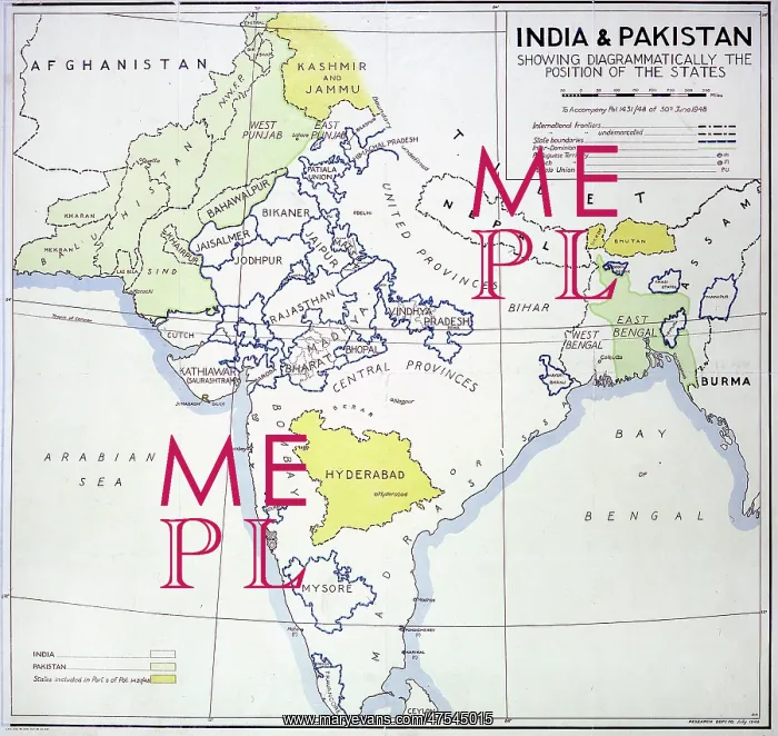


 : Map of India and Pakistan


Map of India and Pakistan

India and Pakistan, showing States, and areas allocated to neither new country, 1948

Picture No
10474698
Media ID
47545015
Size
2443px x 2311px (7.1MB)
Credit
Mary Evans / The National Archives, London. England
Date
1948
Pick your License

Please tell us the book title or ISBN

Please supply intended use


1145 Allocated


Features In These Collections

> Contributors > NAT

You May Also Like


Gallery Wall Inspiration

Thomas Andrews
Keep Our Secrets Secret
Operation Mincemeat - photograph of girlfriend
Indian soldiers at Portsmouth Dock Yard
Victorian Wallpaper - containing arsenic
WW1 Trench map - Somme Battlefield
WW2 - Home Front - Make-do and Mend Poster
Census entry for William Toye
The Domesday Book
16th century codes - the Babington cipher
The Tide Letter from Princess Elizabeth to Queen Mary I
The Great Train Robbery


© Copyright Mary Evans Picture Library - All Rights Reserved 2026
Powered by Media Storehouse®
We accept all major payment options so you can pay for the things you need in the way that is most convenient for you
Facebook     Twitter     Instagram