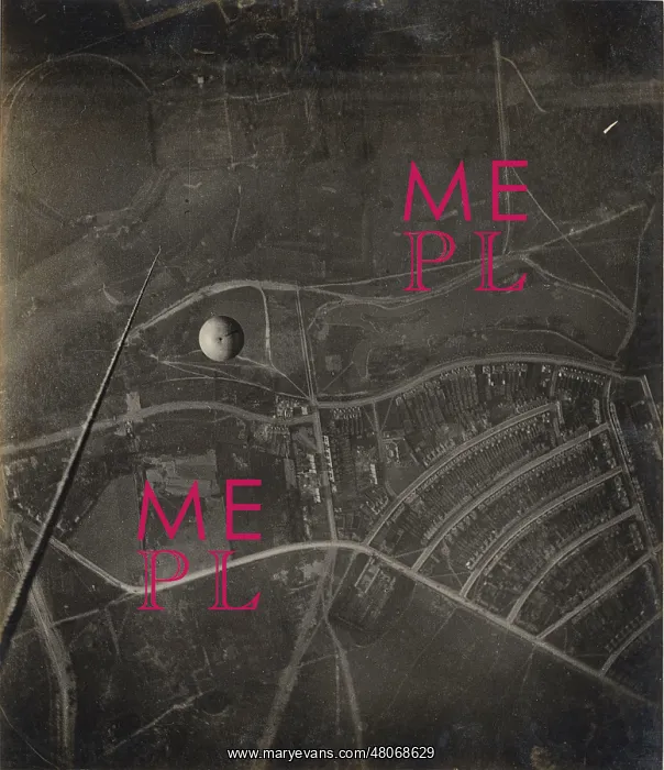
Aerial view of Wanstead from a balloon - 1909
Perhaps the chief interest in this photograph is the actual passing of a balloon under the basket of the one from which this picture was taken. The long straight rope seen to the left of the balloon is the trail rope, three hundred feet long, hanging from the basket of the Corona. The landscape below lies a little to the north west of Great Ilford, with the roads pictured forming Aldersbrook estate, built between 1900-1911 and enclosed here by Aldersbrook Road along the bottom of the picture and Northumberland Avenue between the estate and Wanstead Park. The main village of Wanstead is further north beyond the park. The estate is now a conversation area but at the time this photograph was taken had not been completed with houses on Woodlands Avenue (left) still to be built. Near the top of the picture the large circular figure of The Basin, to the right the cricket ground near the site of Wanstead House. Just below are the Wanstead Golf Links, to the right The Grove in Wanstead Park. Lower down in the picture will be recognised the Resevoir Wood, Shoulder of Mutton Pond and Hesony Pond. The conspicuous road in the foreground is Aldersbrook Road with Aldersbrook Farm at the corner and immediately below are the Wanstead Flats. Blake Hall Road is in the left hand corner. 22 May 1909, 5.10 pm. Balloon Corona
Pick your License
Actual Aldersbrook Basin Conspicuous Corona Flats Grove Ilford Immediately Links Mutton Perhaps Recognised Wanstead
Features In These Collections
> Contributors > RAS