
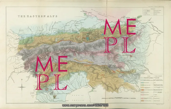
Geological map of the eastern Alps (1832)
Geological map of the eastern Alps, by Roderick Murchison (1792-1871). Hand coloured engraving
Picture No
14160645
Media ID
48657928
Size
4882px x 3110px
(2.1MB)
Credit
© The Geological Society / Mary Evans
Source
Geological Society of London. Accompanied the paper: Sedgwick, A and R I Murchison, A Sketch of the Structure of the Eastern Alps; with Sections through the Newer Formations on the Northern Flanks of the Chain, and through the Tertiary Deposits of Styria, etc. etc. , Transactions of the Geological Society of London', Series 2, Vol 3 (1832), pp 301-420 - Image reference: 07-194
Date
1832




















![Earliest geological map of Ireland [1814]](/sq/800/earliest-geological-map-ireland-1814-48658336.jpg.webp "Earliest geological map of Ireland [1814]")



![Draft of the first geological map of Jersey [c.1828]](/sq/800/draft-first-geological-map-jersey-c1828-48658294.jpg.webp "Draft of the first geological map of Jersey [c.1828]")
![First geological map of Jersey [c.1828]](/sq/800/first-geological-map-jersey-c1828-48658274.jpg.webp "First geological map of Jersey [c.1828]")

![First Geological Map of Scotland [1808]](/sq/800/first-geological-map-scotland-1808-48658245.jpg.webp "First Geological Map of Scotland [1808]")


