
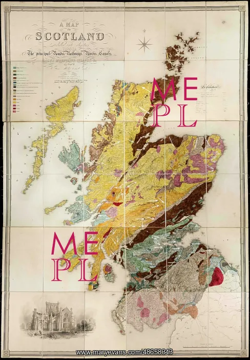
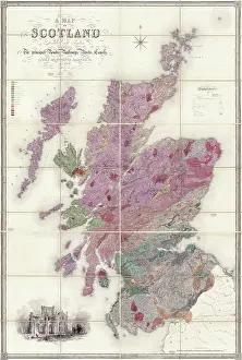
Greenough's and Sharpe's Geological Map of Scotland
Geological map of Scotland [1852], by Daniel Sharpe (1806-1856) and George Bellas Greenough (1778-1855). On the 23 July 1851, a committee headed by George Bellas Greenough, was tasked with assessing the Society's Map collection holdings and make suggestions to improve their availability for the Geological Society's Fellows. Their report on 17 December 1851 recommended that a copy of Samuel Lewis A map of Scotland divided into counties shewing the principal roads, railways, rivers, canals, lochs, mountains, islands, etc be purchased and a further committee existing of Greenough and Daniel Sharpe should undertake its geological colouring. The annotation on the map indicates that it was solely the work of Daniel Sharpe and therefore has been historically catalogued as such. However there are a number of draft versions survive in Greenough's own map collection which were presumably created as part of this project. For instance anothre fair copy version (LDGSL/947/6/C/5) on the same base map uses a slightly different colour scheme, ie gneiss is pink on that map, but yellow on this final version. Hand colouring on engraved base map
Pick your License
1778-1855 1852 Annotation Assessing Availability Bellas Canals Catalogued Colouring Counties Divided Draft Existing Fellows Further Geological Gneiss Greenough Greenoughs Historically Holdings However Improve Indicates Instance Lochs Presumably Purchased Recommended Scheme Sharpe Shewing Solely Suggestions Survive Tasked Therefore Undertake Uses Versions
Features In These Collections
> Contributors > GSO






















![Earliest geological map of Ireland [1814]](/sq/800/earliest-geological-map-ireland-1814-48658336.jpg.webp "Earliest geological map of Ireland [1814]")



![Draft of the first geological map of Jersey [c.1828]](/sq/800/draft-first-geological-map-jersey-c1828-48658294.jpg.webp "Draft of the first geological map of Jersey [c.1828]")
![First geological map of Jersey [c.1828]](/sq/800/first-geological-map-jersey-c1828-48658274.jpg.webp "First geological map of Jersey [c.1828]")

![First Geological Map of Scotland [1808]](/sq/800/first-geological-map-scotland-1808-48658245.jpg.webp "First Geological Map of Scotland [1808]")


