
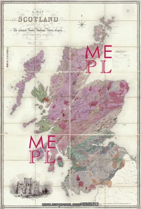
Greenoughs and Sharpe's Geological Map of Scotland
Geological Map of Scotland [1852], by George Bellas Greenough (1778-1855) and Daniel Sharpe (1806-1856). On 23 July 1851 a committee headed by George Bellas Greenough was appointed by Council to assess the extent of the Society's Map collection holdings and make suggestions as to its improvement. One of the recommendations was that a new geological map of Scotland should be produced. Council ordered that the Society should purchase a copy of Lewis Map of Scotland and that a further committee comprising of Greenough and Daniel Sharpe should undertake its geological colouring. This copy is one of three drafts which are extant in the archive of the collection of George Bellas Greenough. The neat colouring indicates that it was probably intended to be the final, finished copy. Instead a further version was produced with a slightly different colour scheme. Watercolour on engraved base
Pick your License
1778-1855 1852 Appointed Assess Bellas Colouring Comprising Drafts Extant Extent Finished Further Geological Greenough Greenoughs Holdings Improvement Indicates Instead Intended Neat Ordered Purchase Recommendations Scheme Sharpe Suggestions Undertake
Features In These Collections
> Contributors > GSO



















![Earliest geological map of Ireland [1814]](/sq/800/earliest-geological-map-ireland-1814-48658336.jpg.webp "Earliest geological map of Ireland [1814]")



![Draft of the first geological map of Jersey [c.1828]](/sq/800/draft-first-geological-map-jersey-c1828-48658294.jpg.webp "Draft of the first geological map of Jersey [c.1828]")
![First geological map of Jersey [c.1828]](/sq/800/first-geological-map-jersey-c1828-48658274.jpg.webp "First geological map of Jersey [c.1828]")

![First Geological Map of Scotland [1808]](/sq/800/first-geological-map-scotland-1808-48658245.jpg.webp "First Geological Map of Scotland [1808]")


