
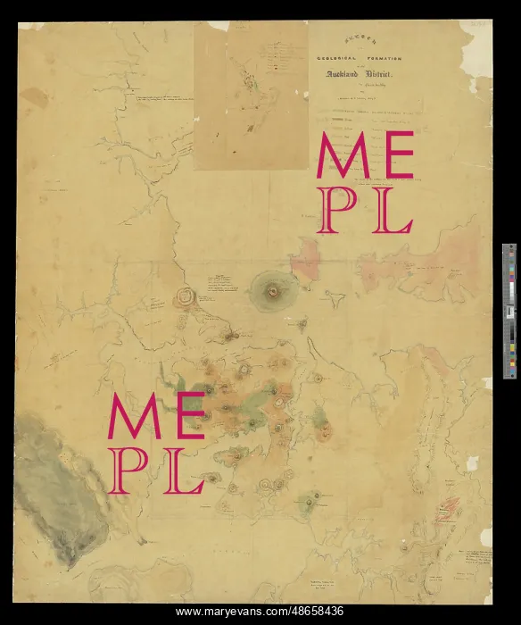
Sketch of the Geological Formation of the Auckland District
Sketch of the Geological Formation of the Auckland District (1857-1859), by Charles Heaphy ([1820]-1881). The artist and colonial surveyor Charles Heaphy ([1820]-1881) arrived in New Zealand in August 1839 initially as draughtsman in the employ of the New Zealand Company. This company was a commercial enterprise whose remit was to systematically (and socially engineer) the colonisation of New Zealand. Heaphy's role was to produce idyllic images of the landscape to tempt Europeans to emigrate. Much of the volcanic landscape depicted by Heaphy in the map is now obscured by urbanisation. This large map was submitted to the Society with Heaphy's paper On the Volcanic Country of Auckland, New Zealand which was published in the Quarterly Journal of the Geological Society, vol 16, (1860), pp242-252. Only part of the map was published. Watercolour
Pick your License
1839 1857-1859 Auckland Colonisation Draughtsman Emigrate Employ Enterprise Geological Idyllic Initially Journal Obscured Produce Quarterly Socially Submitted Surveyor Systematically Tempt Urbanisation Volcanic
Features In These Collections
> Contributors > GSO





















![Earliest geological map of Ireland [1814]](/sq/800/earliest-geological-map-ireland-1814-48658336.jpg.webp "Earliest geological map of Ireland [1814]")



![Draft of the first geological map of Jersey [c.1828]](/sq/800/draft-first-geological-map-jersey-c1828-48658294.jpg.webp "Draft of the first geological map of Jersey [c.1828]")
![First geological map of Jersey [c.1828]](/sq/800/first-geological-map-jersey-c1828-48658274.jpg.webp "First geological map of Jersey [c.1828]")

![First Geological Map of Scotland [1808]](/sq/800/first-geological-map-scotland-1808-48658245.jpg.webp "First Geological Map of Scotland [1808]")


