
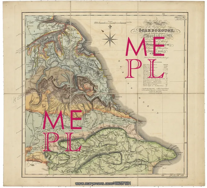
Geological map of Scarborough (Smith, 1831)
Geological colouring by William Smith (1769-1839), on the base map A map of the country round Scarborough in the North and East Ridings of Yorkshire from actual trigonometrical survey with topographical geological and antiquarian descriptions by Robert Knox of Scarborough, published June 1, 1821'. Signed and dated by Smith on the bottom right hand corner. Smith retired to Scarborough in 1834, but had close associations with the seaside town from 1820. The map is one of Smith's last completed geological works. Hand colouring on printed base map
Picture No
14160591
Media ID
48657881
Size
8754px x 7959px
(15.3MB)
Credit
© The Geological Society / Mary Evans
Source
Geological Society of London. Archive reference: LDGSL/750 - Image reference: 07-131
Date
1831
Pick your License
1769-1839 1821 1831 1834 Actual Antiquarian Associations Colouring Descriptions Geological Knox Retired Ridings Scarborough Survey
Features In These Collections
> Contributors > GSO



















![Earliest geological map of Ireland [1814]](/sq/800/earliest-geological-map-ireland-1814-48658336.jpg.webp "Earliest geological map of Ireland [1814]")



![Draft of the first geological map of Jersey [c.1828]](/sq/800/draft-first-geological-map-jersey-c1828-48658294.jpg.webp "Draft of the first geological map of Jersey [c.1828]")
![First geological map of Jersey [c.1828]](/sq/800/first-geological-map-jersey-c1828-48658274.jpg.webp "First geological map of Jersey [c.1828]")

![First Geological Map of Scotland [1808]](/sq/800/first-geological-map-scotland-1808-48658245.jpg.webp "First Geological Map of Scotland [1808]")


