
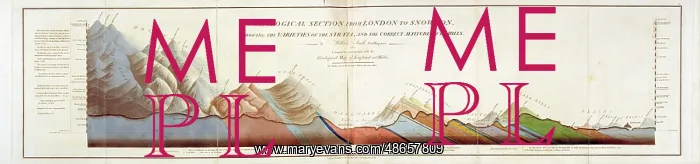
Geological Section from London to Snowdon (Smith, 1817)
Geological Section from London to Snowdon showing the Varieties of the Strata and the Correct Altitudes of the Hills, by William Smith (1769-1839). Hand coloured lithograph
Picture No
14160577
Media ID
48657809
Size
9017px x 2112px
(3.5MB)
Credit
© The Geological Society / Mary Evans
Source
Geological Society of London - Image reference: 07-108
Date
1817
Pick your License
1769-1839 1817 Altitudes Correct Geological Snowdon Strata Varieties
Features In These Collections
> Contributors > GSO






















![Earliest geological map of Ireland [1814]](/sq/800/earliest-geological-map-ireland-1814-48658336.jpg.webp "Earliest geological map of Ireland [1814]")



![Draft of the first geological map of Jersey [c.1828]](/sq/800/draft-first-geological-map-jersey-c1828-48658294.jpg.webp "Draft of the first geological map of Jersey [c.1828]")
![First geological map of Jersey [c.1828]](/sq/800/first-geological-map-jersey-c1828-48658274.jpg.webp "First geological map of Jersey [c.1828]")

![First Geological Map of Scotland [1808]](/sq/800/first-geological-map-scotland-1808-48658245.jpg.webp "First Geological Map of Scotland [1808]")


