
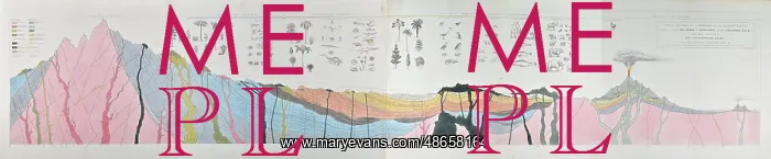
Ideal section of a portion of the Earth's Crust
Ideal section of a portion of the Earth's Crust, intended to shew the order of deposition of the stratified rocks, with their relations to the unstratified rocks'. Selected and arranged by William Buckland, drawn and engraved by Joseph Fisher after original section by Thomas Webster. This section is arguably one of the most influential, and reproduced, geological images of its time. It explains the geological history of the Earth in a horizontal manner (as opposed to the modern geological timescale which is vertical). As its base, the section uses the geochronology popularised by the German geologist Abraham Werner (1749-1817) which split the Earth's history into four broad time periods. These were gradually replaced as the modern geological timescale developed during the 19th century. Lithograph with hand colouring
Pick your License
1836 19th Century Arguably Arranged Buckland Colouring Crust Deposition Developed Explains Geological Geologist Gradually Ideal Intended Manner Opposed Periods Popularised Portion Replaced Reproduced Selected Shew Split Stratified Timescale Uses Webster
Features In These Collections
> Contributors > GSO



















![Earliest geological map of Ireland [1814]](/sq/800/earliest-geological-map-ireland-1814-48658336.jpg.webp "Earliest geological map of Ireland [1814]")



![Draft of the first geological map of Jersey [c.1828]](/sq/800/draft-first-geological-map-jersey-c1828-48658294.jpg.webp "Draft of the first geological map of Jersey [c.1828]")
![First geological map of Jersey [c.1828]](/sq/800/first-geological-map-jersey-c1828-48658274.jpg.webp "First geological map of Jersey [c.1828]")

![First Geological Map of Scotland [1808]](/sq/800/first-geological-map-scotland-1808-48658245.jpg.webp "First Geological Map of Scotland [1808]")


