
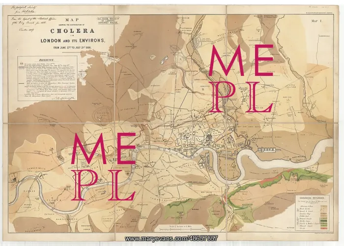
Map showing the distribution of cholera in London
Map showing the distribution of cholera in London and its environs from June 27th-July 21st 1866. In 1866 Britain suffered its fourth epidemic of Asiatic cholera. The creation of this geological map was influenced by the German chemist and public health official Max von Pettenkofer's (1818-1901) now outdated theory that cholera epidemics would only happen under particular circumstances. It relied on three elements combining: the standard of health of the individual; the environmental/meteoric conditions; and the disease fermenting in the groundwater of low level areas. The medical officer J N Radcliffe marked the distribution of cholera deaths which occurred between 27th June and 21st July 1866 on a geological map to analyse whether the localised geological and topographical conditions had any bearing on the infection. Pettenkoffer was indisposed so Radcliffe called upon the services of Society Fellow William Whitaker (1836-1925) to help him. The geology on the map is taken from Robert Mylne's Topographical [and Geological] Map of London and its Environs (1851). The map demonstrates that neither the geology nor the elevation/depression of the land had any bearing as the most affected places shared similar conditions to those which were hardly touched. Instead it shows that the areas with the highest mortality rate shared a common water supply from the Old Ford reservoir operated by the East London Waterworks Company. The intake source on the River Lea was below the outlet for one of the main sewers for London, and the only treatment (filtering) was obstructed during the summer months by thick, slimy growths of algae. Hand-coloured lithograph
Pick your License
1866 27th Affected Algae Analyse Asiatic Cholera Circumstances Combining Deaths Demonstrates Distribution Elements Environs Epidemic Epidemics Fellow Fermenting Filtering Geological Groundwater Growths Hand-coloured Happen Hardly Highest Infection Influenced Instead Intake Level Mortality Neither Obstructed Occurred Operated Outdated Outlet Particular Radcliffe Rate Relied Reservoir Sewers Shared Similar Slimy Source Suffered Theory Thick Touched Waterworks Whether Whitaker
Features In These Collections
> Contributors > GSO




















![Earliest geological map of Ireland [1814]](/sq/800/earliest-geological-map-ireland-1814-48658336.jpg.webp "Earliest geological map of Ireland [1814]")



![Draft of the first geological map of Jersey [c.1828]](/sq/800/draft-first-geological-map-jersey-c1828-48658294.jpg.webp "Draft of the first geological map of Jersey [c.1828]")
![First geological map of Jersey [c.1828]](/sq/800/first-geological-map-jersey-c1828-48658274.jpg.webp "First geological map of Jersey [c.1828]")

![First Geological Map of Scotland [1808]](/sq/800/first-geological-map-scotland-1808-48658245.jpg.webp "First Geological Map of Scotland [1808]")


