
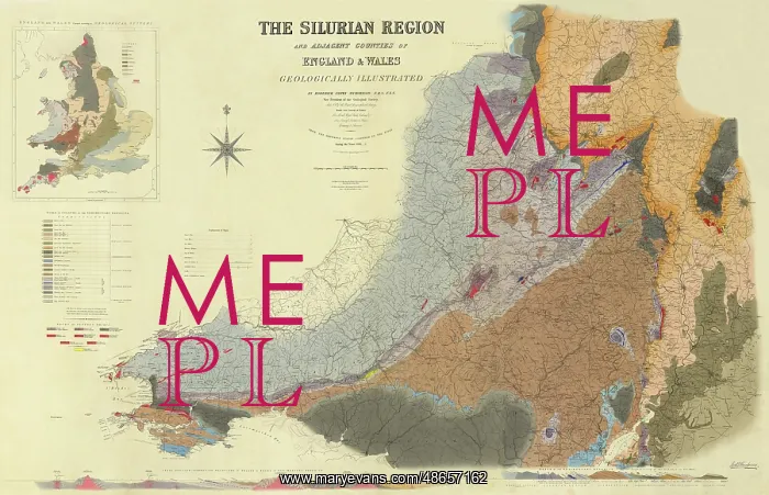
Map of the Silurian Region (Murchison, 1838)
Map of the Silurian Region and adjacent counties of England and Wales geologically illustrated, by Roderick Murchison (1792-1871). In 1839, Sir Roderick Impey Murchison published his seminal work The Silurian system, founded on geological researches in the counties of Salop, Hereford, Radnor, Montgomery, Caermarthen, Brecon, Pembroke, Monmouth, Gloucester, Worcester and Stafford; with descriptions of the coal-fields and overlying formations (London: John Murray), which described the Silurian strata found in South Wales and the West Midlands of England. Included in the text was this map of Siluria as outlined by Murchison, the very first map of Silurian geology in the world. Geological map, ink and watercolours on paper
Pick your License
1792-1871 1838 1839 Adjacent Brecon Counties Described Descriptions Formations Geological Geologically Gloucester Hereford Impey Midlands Monmouth Murchison Outlined Pembroke Radnor Researches Roderick Salop Seminal Silurian Stafford Strata Watercolours Worcester
Features In These Collections
> Contributors > GSO



















![Earliest geological map of Ireland [1814]](/sq/800/earliest-geological-map-ireland-1814-48658336.jpg.webp "Earliest geological map of Ireland [1814]")



![Draft of the first geological map of Jersey [c.1828]](/sq/800/draft-first-geological-map-jersey-c1828-48658294.jpg.webp "Draft of the first geological map of Jersey [c.1828]")
![First geological map of Jersey [c.1828]](/sq/800/first-geological-map-jersey-c1828-48658274.jpg.webp "First geological map of Jersey [c.1828]")

![First Geological Map of Scotland [1808]](/sq/800/first-geological-map-scotland-1808-48658245.jpg.webp "First Geological Map of Scotland [1808]")


