
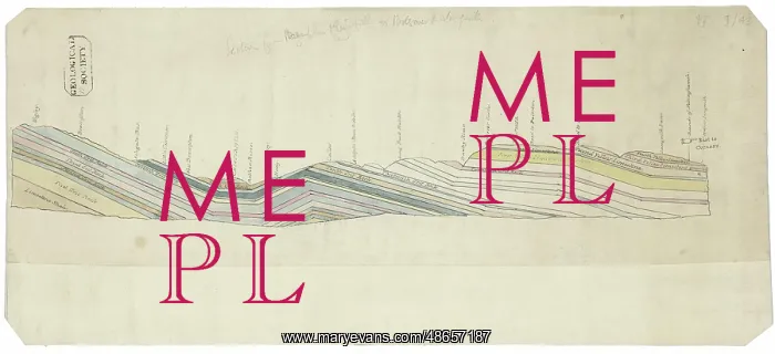
Section of England: Chesterfield to Bolsover
Drawing of a geological cross section across England, from Wigley, Derbyshire, to the county boundary with Nottinghamshire, passing through the settlements of Chesterfield and Bolsover, by George Bellas Greenough (from a drawing by John Farey). Drawing of a geological cross section across England, from Wigley, Derbyshire, to the county boundary with Nottinghamshire, passing through the settlements of Chesterfield and Bolsover. This drawing was presented to the Geological Society by Greenough on 2nd November 1810. Coloured drawing
Picture No
14160519
Media ID
48657187
Size
6875px x 3137px
(2.5MB)
Credit
© The Geological Society / Mary Evans
Source
Geological Society of London. Archive reference: LDGSL/450 - Image reference: 07-07
Date
circa 1810
Pick your License
1810 Bellas Bolsover Boundary Chesterfield Derbyshire Farey Geological Greenough Nottinghamshire Settlements Wigley
Features In These Collections
> Contributors > GSO



















![Earliest geological map of Ireland [1814]](/sq/800/earliest-geological-map-ireland-1814-48658336.jpg.webp "Earliest geological map of Ireland [1814]")



![Draft of the first geological map of Jersey [c.1828]](/sq/800/draft-first-geological-map-jersey-c1828-48658294.jpg.webp "Draft of the first geological map of Jersey [c.1828]")
![First geological map of Jersey [c.1828]](/sq/800/first-geological-map-jersey-c1828-48658274.jpg.webp "First geological map of Jersey [c.1828]")

![First Geological Map of Scotland [1808]](/sq/800/first-geological-map-scotland-1808-48658245.jpg.webp "First Geological Map of Scotland [1808]")


