
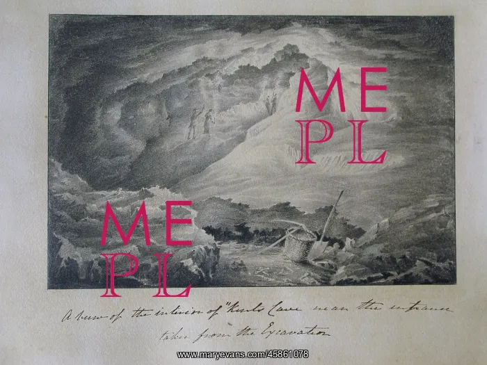
Inside Kent's Cavern
A view of the interior of Kents Cave near the entrance taken from the excavation, by John Marten. Figures with lights held aloft are visible in the background, while in the foreground rest tools presumably used in the excavation to which the title refers. Pencil drawing
Picture No
14154357
Media ID
45861078
Size
4252px x 3189px
(2.7MB)
Credit
© The Geological Society / Mary Evans
Source
Geological Society of London. Archive reference: LDGSL/400/22 - Image reference: 05-30
Date
1825-1826
Pick your License
Aloft Geological Kents Marten Presumably Refers Visible
Features In These Collections
> Contributors > GSO





















![Earliest geological map of Ireland [1814]](/sq/800/earliest-geological-map-ireland-1814-48658336.jpg.webp "Earliest geological map of Ireland [1814]")



![Draft of the first geological map of Jersey [c.1828]](/sq/800/draft-first-geological-map-jersey-c1828-48658294.jpg.webp "Draft of the first geological map of Jersey [c.1828]")
![First geological map of Jersey [c.1828]](/sq/800/first-geological-map-jersey-c1828-48658274.jpg.webp "First geological map of Jersey [c.1828]")

![First Geological Map of Scotland [1808]](/sq/800/first-geological-map-scotland-1808-48658245.jpg.webp "First Geological Map of Scotland [1808]")


