
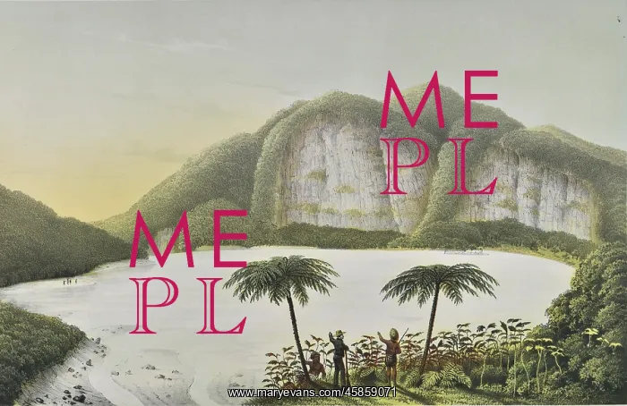
Kawah Putih, Java
Kahwah-Patua ('White crater'), by J Tempeltey. Lithograph of a Kawah Putih, a crater lake, on the island of Java, Indonesia. The lake has formed in one of the two craters of Mount Patuha, a volcano in West Java. It is highly acidic and changes colour depending on the concentration of sulphur. Junghuhn may have been the first person to document this lake in the western world. Lithograph
Picture No
14154153
Media ID
45859071
Size
5934px x 3848px
(3.4MB)
Credit
© The Geological Society / Mary Evans
Source
Geological Society of London. Junghuhn's Landschaften-Atlas zu Java', which accompanied his four volume Java: deszelfs gedaante, bekleeding en inwendige struktuur (Java: its shape, vegetation cover and inner construction)', (Amsterdam: PN Van Kampen, 1850-1854). - Image reference: 02-25a
Date
1850-1854




















![Earliest geological map of Ireland [1814]](/sq/800/earliest-geological-map-ireland-1814-48658336.jpg.webp "Earliest geological map of Ireland [1814]")



![Draft of the first geological map of Jersey [c.1828]](/sq/800/draft-first-geological-map-jersey-c1828-48658294.jpg.webp "Draft of the first geological map of Jersey [c.1828]")
![First geological map of Jersey [c.1828]](/sq/800/first-geological-map-jersey-c1828-48658274.jpg.webp "First geological map of Jersey [c.1828]")

![First Geological Map of Scotland [1808]](/sq/800/first-geological-map-scotland-1808-48658245.jpg.webp "First Geological Map of Scotland [1808]")


