
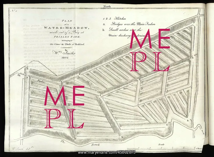
Plan of a Water-Meadow made out of a Bog
Plan of a Water-Meadow made out of a Bog at Prisley Farm belonging to His Grace the Duke of Bedford, by William Smith (1769-1839). Water-meadows are areas of agricultural grassland where irrigation is strictly controlled through the use of sluice gates or hatches to feed in the water, which systematically drains through the meadow, with the excess passing into ditches and drains to be discharged into a river, or in this case a brook. The intention was to keep the ground damp, allowing multiple and larger yields of crops of higher quality of grass for sheep and cattle. William Smith worked on the drainage of the Prisley Bog between 1802-1803. Engraving
Picture No
14154574
Media ID
45862875
Size
3762px x 2749px
(2.0MB)
Credit
© The Geological Society / Mary Evans
Source
Geological Society of London. Observations on the Utility, Form and Management of Water Meadows and the Draining and Irrigation of Peat Bogs, with an Account of Prisley Bog and other Extraordinary Improvements, Conducted for His Grace the Duke of Bedford, Thomas William Coke, Esq,MP, and Others', Norwich: Printed by R M Bacon for Longman, Hurst, Rees and Orme (1806). Plate 2. - Image reference: 23-21
Date
1806
![Geological Map of England and Wales [1839] 2nd edition](/t/800/geological-map-england-wales-1839-2nd-edition-48658196.jpg.webp)



















![Earliest geological map of Ireland [1814]](/sq/800/earliest-geological-map-ireland-1814-48658336.jpg.webp "Earliest geological map of Ireland [1814]")



![Draft of the first geological map of Jersey [c.1828]](/sq/800/draft-first-geological-map-jersey-c1828-48658294.jpg.webp "Draft of the first geological map of Jersey [c.1828]")
![First geological map of Jersey [c.1828]](/sq/800/first-geological-map-jersey-c1828-48658274.jpg.webp "First geological map of Jersey [c.1828]")

![First Geological Map of Scotland [1808]](/sq/800/first-geological-map-scotland-1808-48658245.jpg.webp "First Geological Map of Scotland [1808]")


