
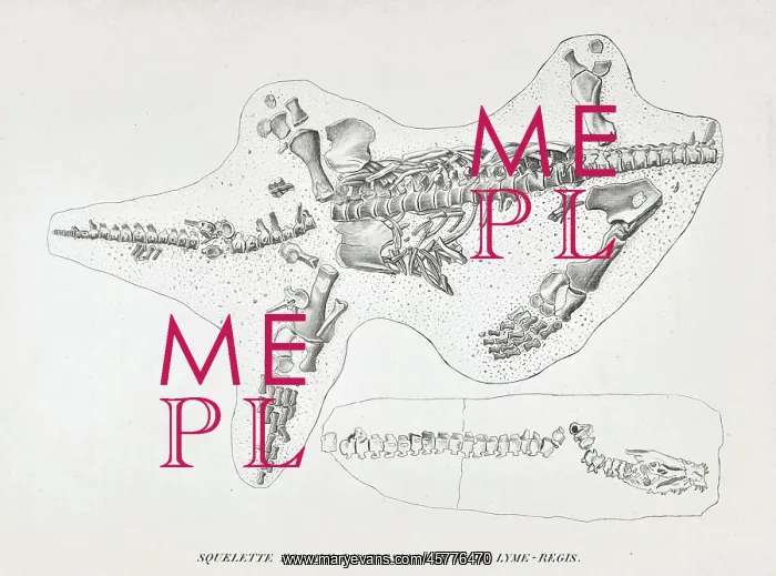


 : Skeleton of a Plesiosaur from Lyme Regis


Skeleton of a Plesiosaur from Lyme Regis

Squellette fossile de plesiosaurus de Lyme-Regis'. Engraving of the second (partially) complete plesiosaur ever discovered. Mary Anning (1799-1847) did not find this fossil herself, instead she purchased it from another local fossil collector for £3 and sold it on for £10 to the French geologist Louis Constant Prevost (1787-1856) during his visit to Lyme Regis in June 1824. The insert showing the head and neck is taken from an engraving of the Plesiosaurus dolichodeirus, the first complete plesiosaur which was found by Anning in Lyme Regis on the 10 December 1823. Engraving

Picture No
14154651
Media ID
45776470
Size
4134px x 3066px (1.5MB)
Credit
© The Geological Society / Mary Evans
Source
Geological Society of London. Cuvier, G, Discours sur les revolutions de la surface du globe, et sur les changemens qu'elles ont produits dans le regne animal. Paris: Chez G. Dufour et Ed. d'Ocagne. (1826), Plate 3. Head and neck insert taken Conybeare, W D, aeOn the Discovery of an almost perfect Skeleton of the Plesiosaurusn, Transactions of the Geological Society of London, Series 2, vol 1 (1824), pp381-389. - Image reference: 27-19
Date
1826

Pick your License

Please tell us the book title or ISBN

Please supply intended use


1799-1847 1823 1824 1826 Anning Collector Constant Discovered Dolichodeirus Geologist Herself Insert Instead Lyme Partially Plesiosaur Plesiosaurus Prevost Purchased Regis


Features In These Collections

> Contributors > GSO

> The Geological Society

Gallery Wall Inspiration

Portrait of Mary Anning (1799-1847)
Uebergangs-Territorium von Christiania (Keilhau 1850)
Delineation of the Strata of England and Wales - Smith
Fossil fish from the collection of William Willoughby Cole
Principal European groups of stratified rocks
Geological views, sections - Essex-Herts - London-Cambridge
Geological view and sections of Norfolk and Suffolk
Geological Sections -Map of the Mining District of Cornwall
Geological view, section through Dorsetshire, Somersetshire
Vertical Section of Strata in Surry (Smith, 1819)
Hydrogeological map of Alnwick and its neighbourhood
Diametric section of the principles and theories of geology
Geognostic map of Sweden (1834)
Sketch of the Geological Formation of the Auckland District
Chart of Sarawak, Borneo (1846)
Geological map of Malta (1856)
Geological Map of England and Wales (1865) 3rd edition
Geological map of Gozo and Cominos, Malta
Greenough's and Sharpe's Geological Map of Scotland
Earliest geological map of Ireland [1814]
Geognostic map of the Harz Mountains (1832)
Island of Arran engraved for an outline of its mineralogy
Jameson's outline map of Scotland (1800)
Draft of the first geological map of Jersey [c.1828]
First geological map of Jersey [c.1828]
Geological Map of England and Wales (1820) 1st edition
First Geological Map of Scotland [1808]


© Copyright Mary Evans Picture Library - All Rights Reserved 2026
Powered by Media Storehouse®
We accept all major payment options so you can pay for the things you need in the way that is most convenient for you
Facebook     Twitter     Instagram













