

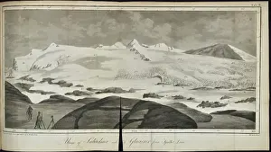
Ustigt af Sulitelma genom Langvandalen, Lapland (1807)
Ustigt af Sulitelma genom Langvandalen (View of Sulitelma through Langvandslen), by Goran Wahlenberg (1780-1851). View showing the location of glaciers in Lapland. Engraving
Picture No
14154512
Media ID
45862132
Size
5700px x 3432px
(2.1MB)
Credit
© The Geological Society / Mary Evans
Source
Geological Society of London. Wahlenberg, Goran, Berattelse om matningar och observationer for att bestamma lappska fjallens hojd och temperatur vid 67 graders polhojd' (Narrative of measurements and observations to decide the altitude and temperature of the Lapland Mountains at 67 degrees north), Stockholm (1808). - Image reference: 09-52
Date
1807





















![Earliest geological map of Ireland [1814]](/sq/800/earliest-geological-map-ireland-1814-48658336.jpg.webp "Earliest geological map of Ireland [1814]")



![Draft of the first geological map of Jersey [c.1828]](/sq/800/draft-first-geological-map-jersey-c1828-48658294.jpg.webp "Draft of the first geological map of Jersey [c.1828]")
![First geological map of Jersey [c.1828]](/sq/800/first-geological-map-jersey-c1828-48658274.jpg.webp "First geological map of Jersey [c.1828]")

![First Geological Map of Scotland [1808]](/sq/800/first-geological-map-scotland-1808-48658245.jpg.webp "First Geological Map of Scotland [1808]")


