

Carte des Etats-Unis de l'Amerique-Nord
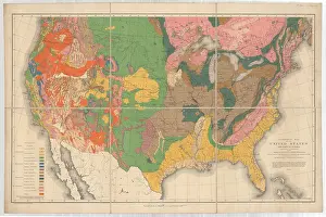
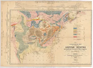
Carte des Etats-Unis de l'Amerique-Nord [Map of North America], by William Maclure. William Maclure (1763-1840), was born in Ayr, Scotland. He became a partner in an American mercantile house and travelled to France and Virginia until 1803 when he returned to Britain. In 1807 he commenced the Herculean task of geologically mapping the United States. His first attempt was published in 1809. This is his second revised version, published in 1811. Maclure published further revisions in 1817. The map delineates the geology based on Wernerian principles of rock classification. Hand coloured. Printed on paper. Dissected and mounted on linen
Pick your License
1803 1807 1809 1811 1817 Carte Classification Commenced Dissected Etats-unis Further Geologically Linen Maclure Mapping Mercantile Partner Principles Returned Revised Revisions Task Travelled
Features In These Collections
> Contributors > GSO



















![Earliest geological map of Ireland [1814]](/sq/800/earliest-geological-map-ireland-1814-48658336.jpg.webp "Earliest geological map of Ireland [1814]")



![Draft of the first geological map of Jersey [c.1828]](/sq/800/draft-first-geological-map-jersey-c1828-48658294.jpg.webp "Draft of the first geological map of Jersey [c.1828]")
![First geological map of Jersey [c.1828]](/sq/800/first-geological-map-jersey-c1828-48658274.jpg.webp "First geological map of Jersey [c.1828]")

![First Geological Map of Scotland [1808]](/sq/800/first-geological-map-scotland-1808-48658245.jpg.webp "First Geological Map of Scotland [1808]")


