

Swanscombe Hill. Looking NNW
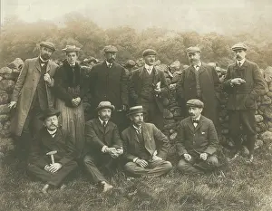
Photograph of Swanscombe Hill, looking NNW, taken during the Watling Street road-widening project, by John Rhodes. From above downwards the sections show the London Clay, the basement bed (where the group of workmen stand) and the Woolwich Sands and Shell-beds. Reproduced in Geology of the Country around Dartford'. Black and white lantern slide
Picture No
14154440
Media ID
45861555
Size
1893px x 1886px
(277KB)
Credit
© The Geological Society / Mary Evans
Source
Geological Society of London. Archive reference: LDGSL/1106 - Image reference: 08-10
Date
1923
Pick your License
Basement Dartford Downwards Reproduced Rhodes Sections Swanscombe Watling Woolwich Workmen
Features In These Collections
> Contributors > GSO





















![Earliest geological map of Ireland [1814]](/sq/800/earliest-geological-map-ireland-1814-48658336.jpg.webp "Earliest geological map of Ireland [1814]")



![Draft of the first geological map of Jersey [c.1828]](/sq/800/draft-first-geological-map-jersey-c1828-48658294.jpg.webp "Draft of the first geological map of Jersey [c.1828]")
![First geological map of Jersey [c.1828]](/sq/800/first-geological-map-jersey-c1828-48658274.jpg.webp "First geological map of Jersey [c.1828]")

![First Geological Map of Scotland [1808]](/sq/800/first-geological-map-scotland-1808-48658245.jpg.webp "First Geological Map of Scotland [1808]")


