
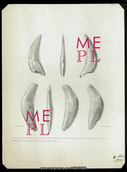
Teeth from Kent's Cavern
Teeth found in the cave of Kent's Hole, near Torquay, Devon by Reverend Mr McEnery, January 1826 in diluvial Mud mix'd with Teeth and gnaw'd Bones of Rhinocerus, Elephant, Horse, Ox, Elk and Deer with Teeth and Bones of Hyaenas, Bears, Wolves, Foxes, etc. by Mary Buckland, George Scharf. Teeth found in Kent's Cavern, along with other teeth and bones of various creatures. Kent's Cavern (known as Kent's Hole until 1903) is a cave system in Torquay, famous for the geological and archaeological finds that have occurred there. The archaeological evidence shows that animals and people have been entering the cave for hundreds of thousands of years. Lithograph
Picture No
14154205
Media ID
45859620
Size
6549px x 8855px
(7.7MB)
Credit
© The Geological Society / Mary Evans
Source
Geological Society of London. Archive reference: LDGSL/56/1/5/2 - Image reference: 03-05
Date
1827-1829



















![Earliest geological map of Ireland [1814]](/sq/800/earliest-geological-map-ireland-1814-48658336.jpg.webp "Earliest geological map of Ireland [1814]")



![Draft of the first geological map of Jersey [c.1828]](/sq/800/draft-first-geological-map-jersey-c1828-48658294.jpg.webp "Draft of the first geological map of Jersey [c.1828]")
![First geological map of Jersey [c.1828]](/sq/800/first-geological-map-jersey-c1828-48658274.jpg.webp "First geological map of Jersey [c.1828]")

![First Geological Map of Scotland [1808]](/sq/800/first-geological-map-scotland-1808-48658245.jpg.webp "First Geological Map of Scotland [1808]")


