
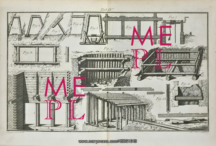
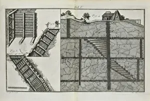
Timber supports for mining
Print showing correct methods of installing timber supports for mining. From Hermann, B F J von. Mineralogische Reisen in Sibirien. Vom Jahr 1783 bis 1796, (1797-1801), plate 4. Hermann was an Austrian geologist, mineralogist and mining engineer, who travelled to St Petersburg in 1781 and entered the service of Catherine the Great, inspecting mines and iron and smelting works in the Urals and Siberia. He produced a number of publications, some printed by his own publishing company, on mining practices and metallurgy. Engraving
Pick your License
1781 1783 1796 1797-1801 Correct Entered Geologist Inspecting Installing Jahr Metallurgy Methods Mineralogist Mines Practices Publications Reisen Siberia Sibirien Smelting Supports Travelled Urals
Features In These Collections
> Contributors > GSO






















![Earliest geological map of Ireland [1814]](/sq/800/earliest-geological-map-ireland-1814-48658336.jpg.webp "Earliest geological map of Ireland [1814]")



![Draft of the first geological map of Jersey [c.1828]](/sq/800/draft-first-geological-map-jersey-c1828-48658294.jpg.webp "Draft of the first geological map of Jersey [c.1828]")
![First geological map of Jersey [c.1828]](/sq/800/first-geological-map-jersey-c1828-48658274.jpg.webp "First geological map of Jersey [c.1828]")

![First Geological Map of Scotland [1808]](/sq/800/first-geological-map-scotland-1808-48658245.jpg.webp "First Geological Map of Scotland [1808]")


