
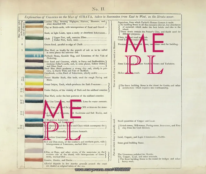
Table of the Explanation of Colours on the Map of Strata
Explanation of Colours on the Map of Strata, taken in Succession from East to West, as the Strata occur. by William Smith (1769-1839). The table was included in the early editions of the printed memoir which accompanied William Smith's geological map A Delineation of the Strata of England and Wales... (1815). Later editions saw the table being replaced by one of the revised versions of A Geological Table of British Organized Fossils'. Hand colouring on engraved base
Picture No
14154577
Media ID
45862887
Size
3466px x 2944px
(1.7MB)
Credit
© The Geological Society / Mary Evans
Source
Geological Society of London. Smith, W, A Memoir to the Map and Delineations of the Strata of England and Wales with part of Scotland', 1815, plate II. - Image reference: 23-25
Date
1815
Pick your License
1769-1839 1815 Colouring Delineation Editions Explanation Fossils Geological Memoir Occur Organized Replaced Revised Strata Succession Versions
Features In These Collections
> Contributors > GSO





















![Earliest geological map of Ireland [1814]](/sq/800/earliest-geological-map-ireland-1814-48658336.jpg.webp "Earliest geological map of Ireland [1814]")



![Draft of the first geological map of Jersey [c.1828]](/sq/800/draft-first-geological-map-jersey-c1828-48658294.jpg.webp "Draft of the first geological map of Jersey [c.1828]")
![First geological map of Jersey [c.1828]](/sq/800/first-geological-map-jersey-c1828-48658274.jpg.webp "First geological map of Jersey [c.1828]")

![First Geological Map of Scotland [1808]](/sq/800/first-geological-map-scotland-1808-48658245.jpg.webp "First Geological Map of Scotland [1808]")


