
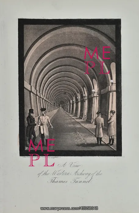
The Western Archway of the Thames Tunnel
View of the Western Archway of the Thames Tunnel, by Robert Cruikshank after sketch by M Dixie. The idea of a tunnel between Rotherhithe and Wapping was suggested by the civil engineer Marc Brunel (1769-1849) in 1824. A Parliamentary Bill for the Thames Tunnel Company for Making and Maintaining a tunnel under the Thames was given Royal Assent in 1824, with work on the shaft at Rotherhithe beginning in March 1825. Two previous attempts at constructing a tunnel under the Thames had failed due to water ingress, but Marc Brunel's tunnel was to use his patented tunnelling shield. The shield provided support to the mining operation whilst the tunnel was encased securely in brickwork. It comprised a series of fixed and adjustable frames that inched forward at a rate of initially around eight feet per week as the tunnelling progressed. In the spring of 1827, the first major flood stopped work. Work restarted in the winter of 1827 and by the time the commemorative volume was published in 1838 the tunnel had flooded a further four times. In November 1841 the tunnelling reached Wapping. The tunnel was finally open in 1843. Tinted lithograph
Pick your License
1769-1849 1824 1825 1827 1838 1841 1843 Adjustable Archway Assent Attempts Brickwork Brunel Brunels Commemorative Comprised Constructing Cruikshank Dixie Encased Failed Finally Fixed Flooded Frames Further Idea Inched Ingress Initially Maintaining Parliamentary Patented Previous Progressed Provided Rate Reached Restarted Rotherhithe Securely Shaft Stopped Suggested Tinted Tunnelling Wapping Whilst
Features In These Collections
> Contributors > GSO





















![Earliest geological map of Ireland [1814]](/sq/800/earliest-geological-map-ireland-1814-48658336.jpg.webp "Earliest geological map of Ireland [1814]")



![Draft of the first geological map of Jersey [c.1828]](/sq/800/draft-first-geological-map-jersey-c1828-48658294.jpg.webp "Draft of the first geological map of Jersey [c.1828]")
![First geological map of Jersey [c.1828]](/sq/800/first-geological-map-jersey-c1828-48658274.jpg.webp "First geological map of Jersey [c.1828]")

![First Geological Map of Scotland [1808]](/sq/800/first-geological-map-scotland-1808-48658245.jpg.webp "First Geological Map of Scotland [1808]")


